View my Instagram feed here:
If you have any questions, or comments – drop me a line.
View my Instagram feed here:
If you have any questions, or comments – drop me a line.
We picked up my passport and truck (1991 Toyota Landcruiser FJ80) in Edmonton, and headed south. November 23 – December 6th. Pictures taken with a Leica M240 with Leica -R 19mm lens, Nikon D700 with Nikkor 17-35mm lens. Photos processed in Lightroom. If you have any questions, or comments – drop me a message.

Bernadette – finishing off a pair of socks while i waited in line at Service Canada for 10 hours to pick up my new passport.

Short visit to the Landcaster Museum in Nanton, Alberta. Check out that ancient Avro CF-100 ‘Clunk’ jet, and the equally ancient Landcruiser !
We simply ‘passed through’ Montana. Road pictures only. Photo gallery below.


In Virgin Utah, we drove up Hurricane Mesa for un-impeded views of Zion National Park, and drove across the Mesa to the entrance to Zion National Park. Awe-inspiring views of the coloured sedimentary rocks. Photo gallery below.


At Logandale we entered the ‘Logandale Trails’ off-road area. Intended primarily for quads and side-by sides. The roads were no problem for our Landcruiser. Again, more red-coloured rocks, although tilted. To the east, on the horizon, perfectly horizontal layers of sedimentary rocks. We passed the parking lot full of campers and RV’s, and empty trailers for off-road vehicles and had the area to ourselves. We camped here for 2 nights, and had a little fun making shadows of ourselves with the truck headlights. Photo gallery below.


Valley of Fire is characterized by layers of bright red sandstone and grey limestone. The sandstone was deposited during the Jurassic period (201.3 million to 145 million years ago), by the wind after inland seas subsided and the land rose. Photographically the conditions were challenging – bright sun and no clouds, as such the photos appear over contrasty. we did an early morning walk – but got in trouble from the Park Ranger because we were walking on the road (not a vehicle to be seen for miles !). Yes, the rumour it true – I did knit myself a scarf !. Photo gallery below.


Casino signs are everywhere in downtown Los Vegas. E very casino seems to be in competition with the most eye catching signs. Through my lens, the “Better” casino signs are neon, or have 100’s of small bulbs. I wonder how often the bulbs have to be changed out ;>. If you have any questions or comments- drop me a line.


Selected images from a walk around the older (and much less popular) part of down town Los Vegas.


These photo were posted on my Flickr account (SteveSchwarzPhotography). I no longer upload to this account. The photos below link directly to the Flickr account. If you have any questions, or comments about these photos – drop me aline,

Location
Baillie Island is located at the northern tip of Cape Bathurst, the most northern portion of mainland NWT.
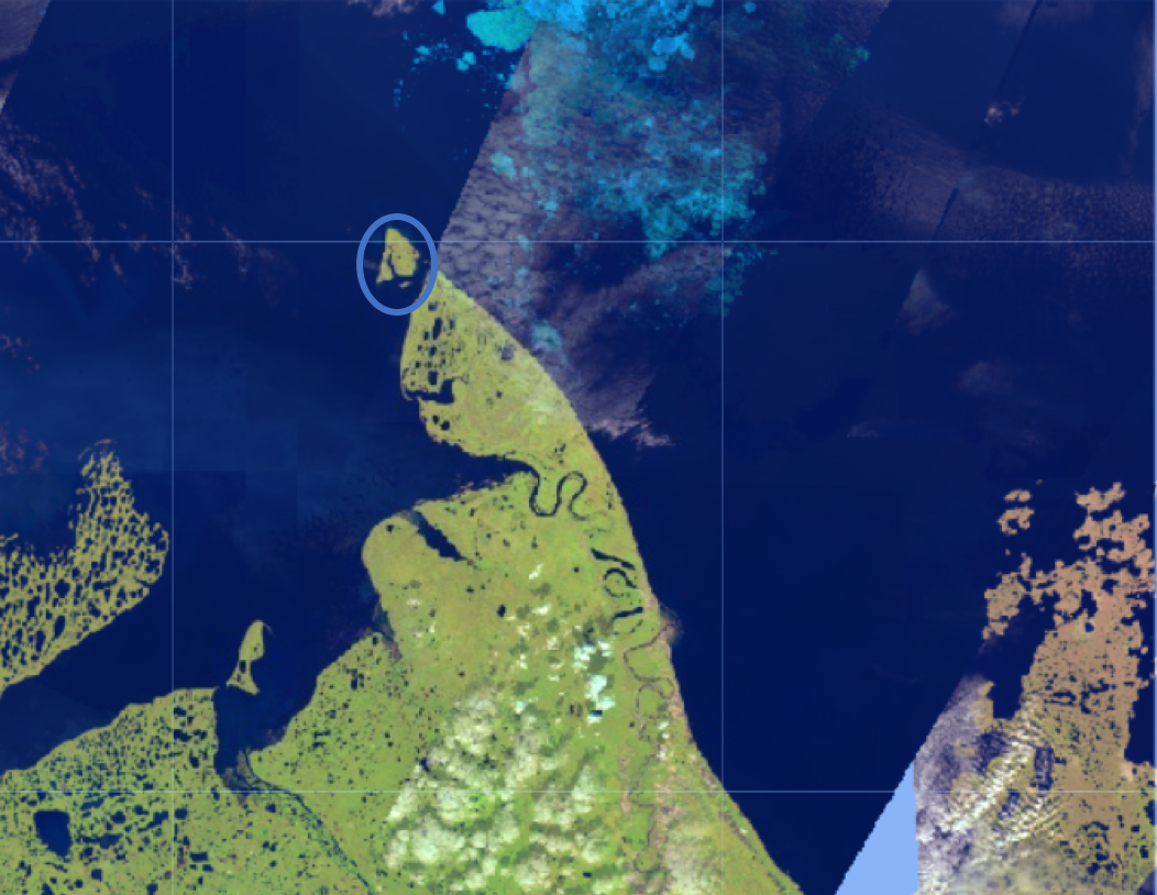
This area is of importance due to the occurrence the rare hairy rockcress or hairy braya (Braya pilosa, genus Braya of family Brassicaceae) that is observed at five locations on the Baillie Islands and Cape Bathurst.
Methodology
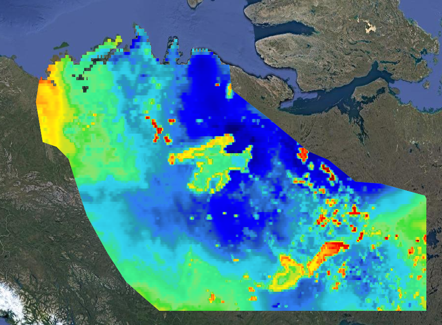
Two different methods were used to measure coastal erosion on Braille Islands. Both methods use an early and later (most recent satellite image). The measure distance between the coastline of earlier and coastline of the later satellite image is inferred to be the amount of coastal erosion between the date of the earlier image and the date of the later image. The difference between Method-1, and Method-2 is the time span between the earlier and later image, and the resolution of the satellite imagery. Method-1 uses the earliest available moderate resolution (30m) Landsat satellite imagery 1985-2021, where as Method-2 users the higher resolution Sentinel-2 (20m) using available dates (2017-2021). Five (A-G) cross sections were used for measuring the distance between the earlier and later satellite image. This was done in ArcGIS Pro. The process of measuring involves subjective interpretation in respect to measuring a smooth surface (thick blue line) of a raster (pixelated) image (see image below).
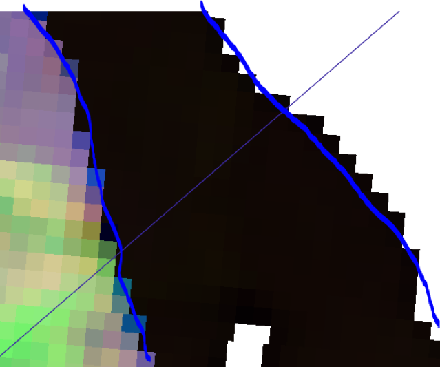
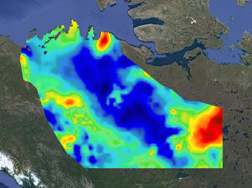
As Sentinel-2 imagery has a finer resolution than Landsat (20m vs 30m) the pixels are smaller, and thus assumed to be closer to the smooth surface representing the actual coastline.
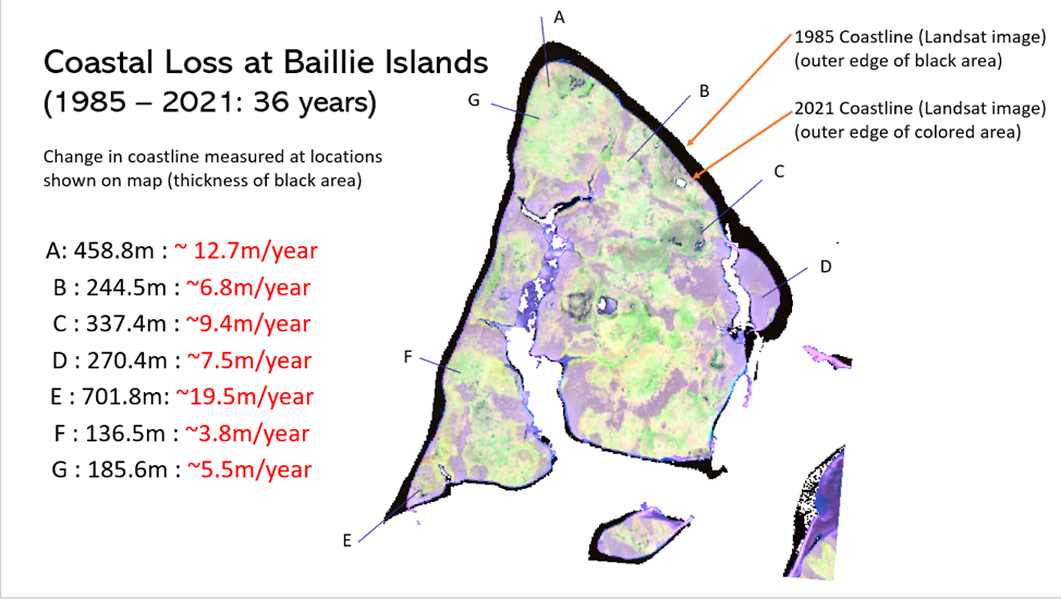
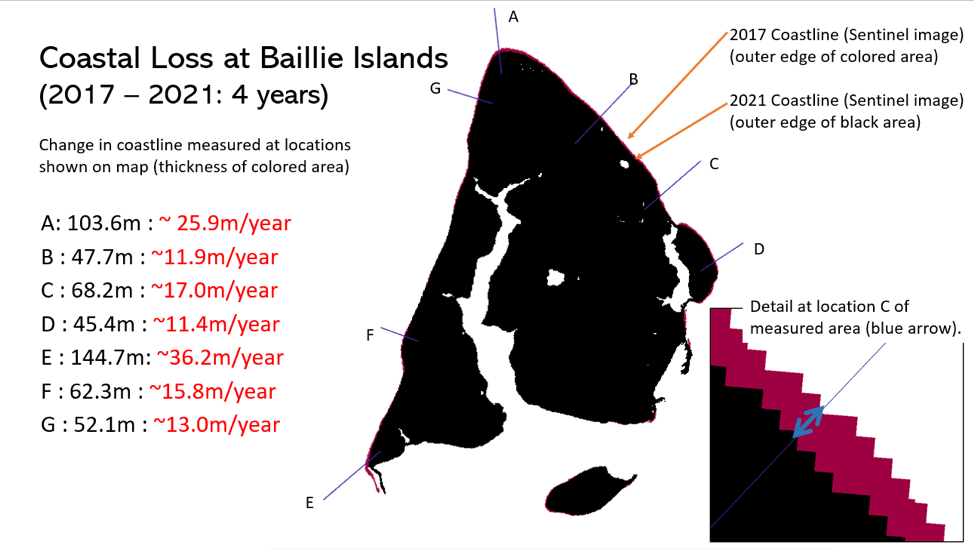
Measured distances between the earlier and later satellite images were divided by the time interval between the earlier and the later images, and shown in red in the following Figures.
Method-1
This method uses Landsat (1985-2021) imagery for measuring of coastal erosion.
Method-2
This method uses available Sentinel-2 imagery.
Summary
Noting that the date range for Method-1 spans 36 years and 4 years in Method-2, the measured distances at the five cross sections differ significantly. There may be a number of reasons, including the coarser pixel size of the Landsat imagery, and corresponding errors in the subjective interpretation of the measurement between the earlier and later images. There is the possibility that there has been an increase in coastal erosion during the later time interval, thus shewing the averaged erosion rate when divided by the time interval between the earlier and later images.
Easter long weekend cruise on the ice roads on Great Slave Lake (Yellowknife, Northwest Territories).
This 110km long and 1.1m thick ice road heads from Yellowknife to the Vital Metals Ltd. Nechalacho rare earths project at Thor Lake near the Hearne Channel of Great Slave Lake. All heavy equipment for the mine was transported on this road.
On Saturday (May 8th) the light was poor and road conditions made road difficult to drive. Actually quite difficult to see the road. On Sunday (May 9th) the road was freshly plowed and sunny sky. We drove the Yellowknife – Devils Channel (Gros Cap) section (75km) and skied 11km in Devil’s Channel that separates Gros Cap from the mainland. No other traffic on the road. On the return, due to the warm temperatures in the afternoon and cooling evening temperatures the large and deep puddles on the crystal clear ice were partially frozen – peppering the hood and windshield with chunks of ice. The ice road was closed 12hours after we got home.
Anticipating that things can go wrong on a remote ice road, we brought safety and survival gear, including the rooftop tent, -30C sleeping bags, warm clothes, food, stove, inreach, extra fuel, winch, ice screws, towing strap, and Maxtracks.
Pictures from Saturday:


Pictures from (sunny) Sunday:


The past couple of months I have been writing code in Google Earth Engine (GEE). For those that don’t know what GEE is – in brief is a database of satellite imagery and a code window to create a run scripts. Data can be uploaded to the GEE platform, and exported (downloaded). The database of satellite imagery includes recent (today) and historical data (as far back as 1972) depending to the type of satellite. Landsat data is continuous from 1972 – current, Sentinel 1 (2014- current), Sentinel-2 (2016-current), and other satellites have shorter time periods (2000-current). In essence, the availability of historical data provides a means to “move back” in time, where as the current and yet-to be collected data provides a means to move forward in time.
Air temperature Trend (2000-2020)
In this post I will demonstrate a couple of GEE Mapping Tools that I created in GEE to illustrate 20 year Trends (2000-2020) in Air Temperature, Snowfall/snow depth/density/temperature, and Lake ice-temperatures across the NWT.
NWT Snowfall Trend (2000-2020)
Click on the links below to view the Mapping Tool
NWT Climate Trends Mapping Tool
A typical photospread. No need to add much text, as there are are plenty of more wordy places to learn about Zion, Canyonlands and Arches National Park. I didn’t even include a map (seems odd for a guy that makes maps for a living).
Cameras used; Leica M240 with Leica-R 19mm, and Fuji X-Ti with Fujinon 14mm


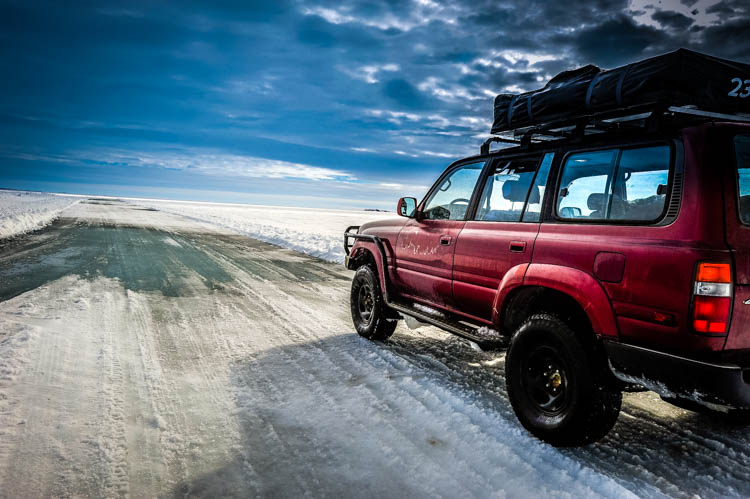
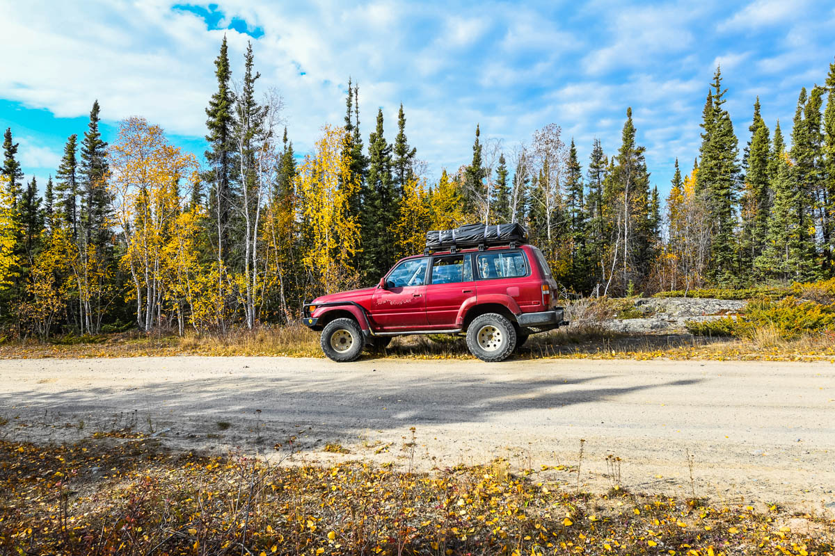
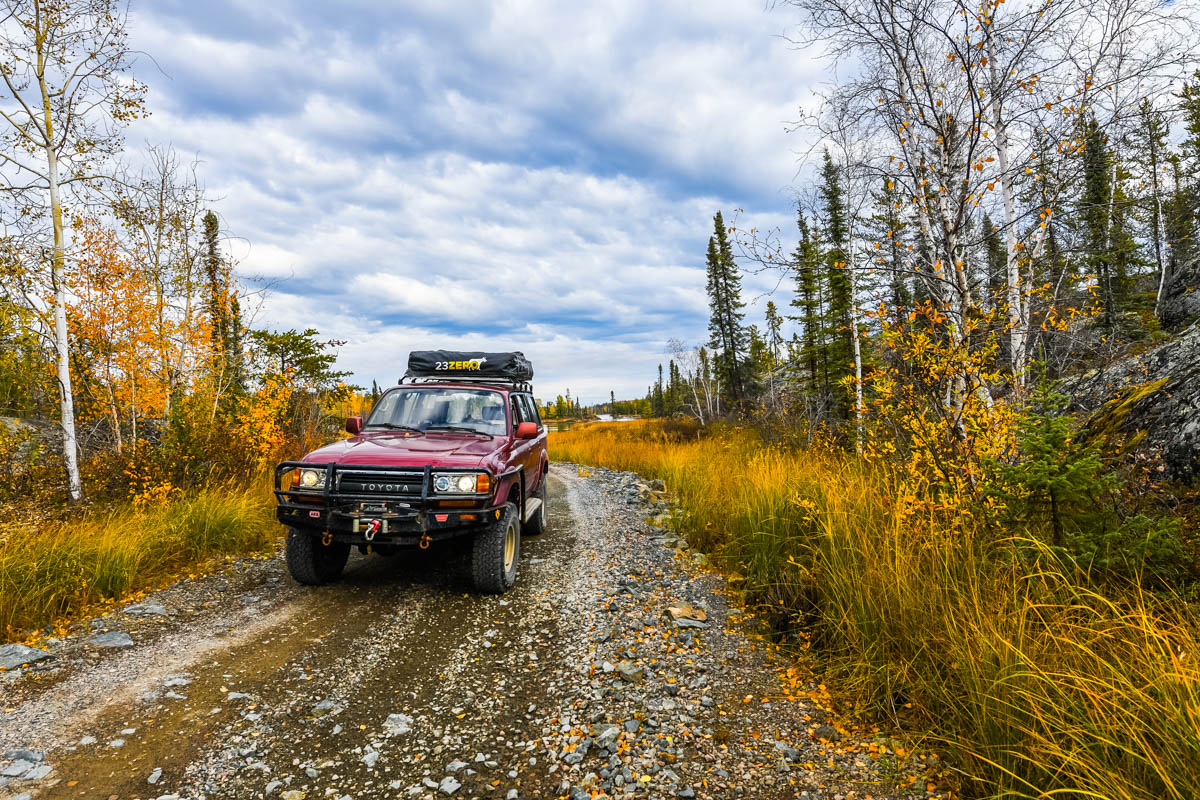
One of the youngest trucks in my fleet – Only 31 years old !.
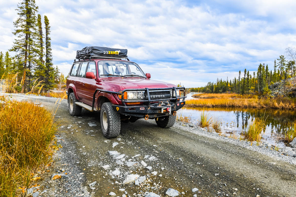
It is a US truck, in miles – slightly confusing when the speed limits in Canada are in Km. Compared to most trucks of its age (e.g. old battered Ford pickups), there is no rust and a few small dents and scratches. It does have a crack in the windshield, though where I live that is considered normal. The combination of extreme cold and gravel roads makes cracked windshields inevitable.
It has a ARB front bumper, Warn Zeon 12 winch, ARB airlocker on rear differential, 2.5″ Old Man Emu heavy lift, rocker guards and a 23Zero rooftop tent on a DIY roof rack with Smittybuilt + 8020 rails.
Needs minor things like a new windshield, mudflaps, and flares. Mechanically very solid.
Maintained properly for the past 4 years for sure, can’t speak past that as no records.
I count the emission delete as an upgrade lol.

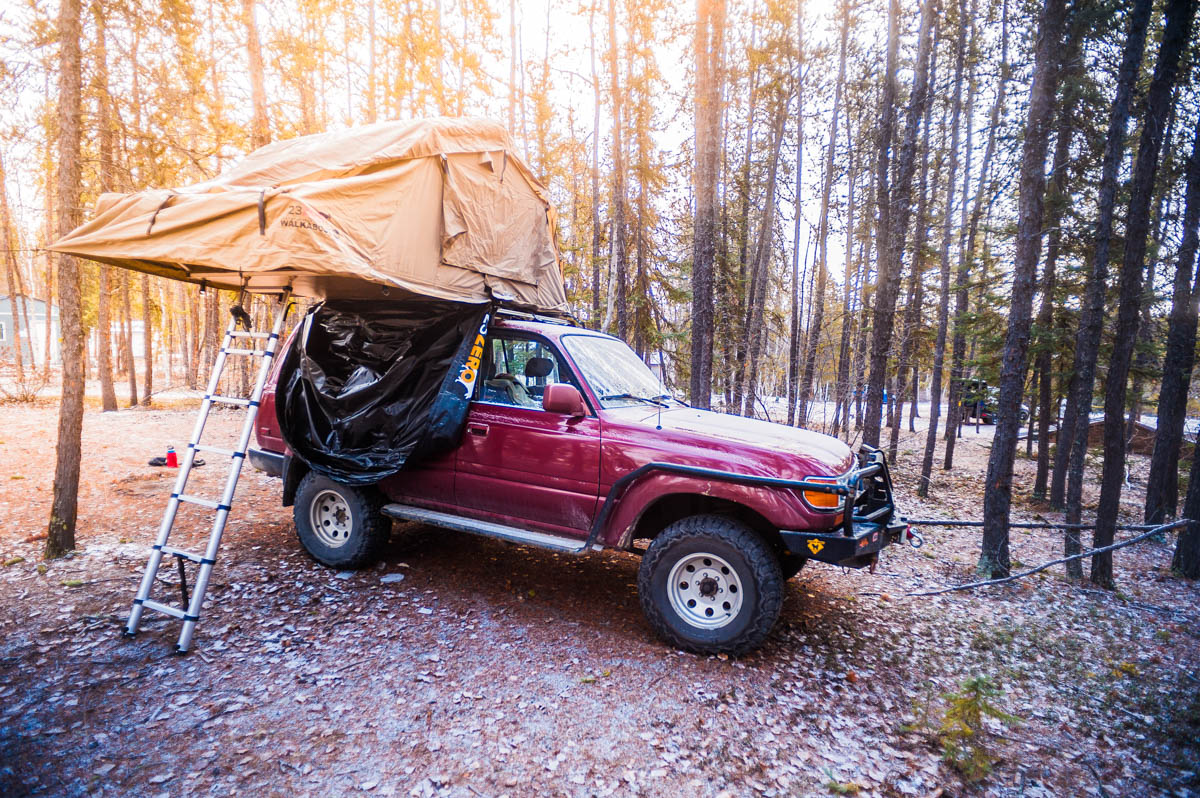


For winter use, the is a liner for the 23Zero tent and a Propex2000 heater.
Really tempted to have a Campteq poptop tent installed for additional headroom.
Got any questions or comments – Drop me a line.
Check out my Instagram feed…
Error: No feed with the ID 1 found.
Please go to the Instagram Feed settings page to create a feed.
