These photo were posted on my Flickr account (SteveSchwarzPhotography). I no longer upload to this account. The photos below link directly to the Flickr account. If you have any questions, or comments about these photos – drop me aline,
These photo were posted on my Flickr account (SteveSchwarzPhotography). I no longer upload to this account. The photos below link directly to the Flickr account. If you have any questions, or comments about these photos – drop me aline,

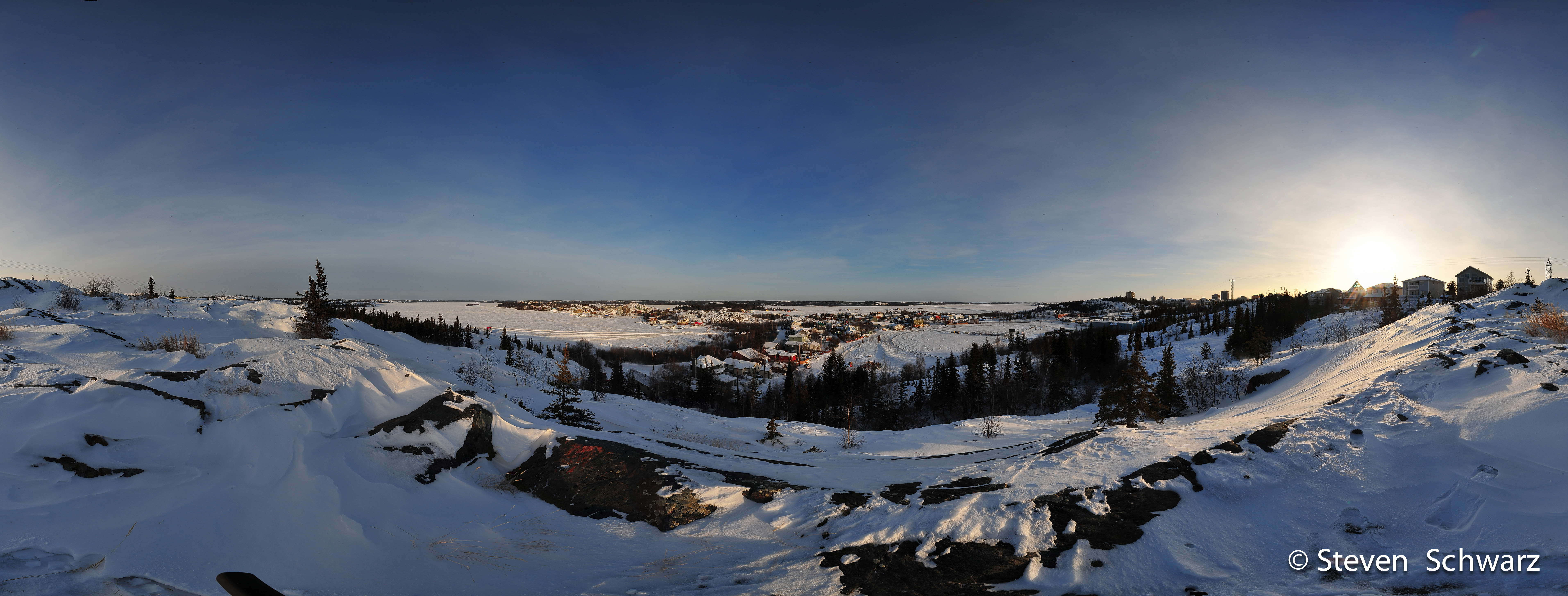
Twin Pine Hill – one of best places to enjoy a scenic view of Old town Yellowknife, and Great Slave Lake. These 360 degree panoramas were created from photos taken on May 18th, 2014.
In this view, Old Town is in the distance, to the north. Franklin Avenue (center of photo) separates Peace River Flats and Willow Flats (right side) and continues to Latham Island and N’Dilo in the distance. If you look carefully, the melted remnants of the Snow Castle can be seen, along with house boaters commuting across the ice, and a even a kite skier behind the houseboats.

Click on the image for a larger view.
To view the 360 degree animation. Click Here. This requires the QuickTime Player. Click the icon on the upper right corner of the animation to get a full view. Depending on network speed, the image may take a moment to load.
In this image, along the ridge to the southeast of the previous photo, Old Town (Willow Flats) is on the far left. The road winding up the hill is School Draw, an the remains of a recently burnt house can be seen in the center part of the photo.

Click on the image for a larger view.
To view the 360 degree animation. Click Here. This requires the QuickTime Player. Click the icon on the upper right corner of the animation to get a full view. Depending on network speed, the image may take a moment to load.
These panoramas were created by combining 5 photos (4 photos at 90 degrees to each other, and the fifth taken straight down at my feet to fill in a gap), using a Nikon D700, a ‘shaved’ Samyang 8mm lens with a custom built panorama head see Making Panoramas with a DIY Panoramic Head and a Monopole. The hardest part of making these panoramas was photoshopping out all the garbage and smashed bottles…

Pilot’s Monument is the best place to go for a scenic view of Yellowknife Bay, Old Town, with its unique character and Downtown Yellowknife (actually up the hill from Old Town). After climbing the stairs to the top of the hill, the view is spectacular. At the top there is a brass plaque as a tribute to northern pilots.
In this image, downtown Yellowknife is directly under the sun on the right side of the image. Pilot’s Monument is in the middle of the photo, and Back Bay is on the far left.

Click on the image for a larger view.
To view the 360 degree animation. Click Here. This requires the QuickTime Player. Click the icon on the upper right corner of the animation to get a full view. Depending on network speed, the image may take a moment to load.
Camera gear: Nikon D700 and a Peleng 8mm lens on a custom monopole. Six pictures were combined to create the panorama images on this page.

Bullocks Bistro, in Old Town Yellowknife serves up the best fish in town, and is often featured on CBC Arctic Air. Can’t think of too many restaurants that actually let you, and encourage you to leave your mark on the ceilings and walls !.
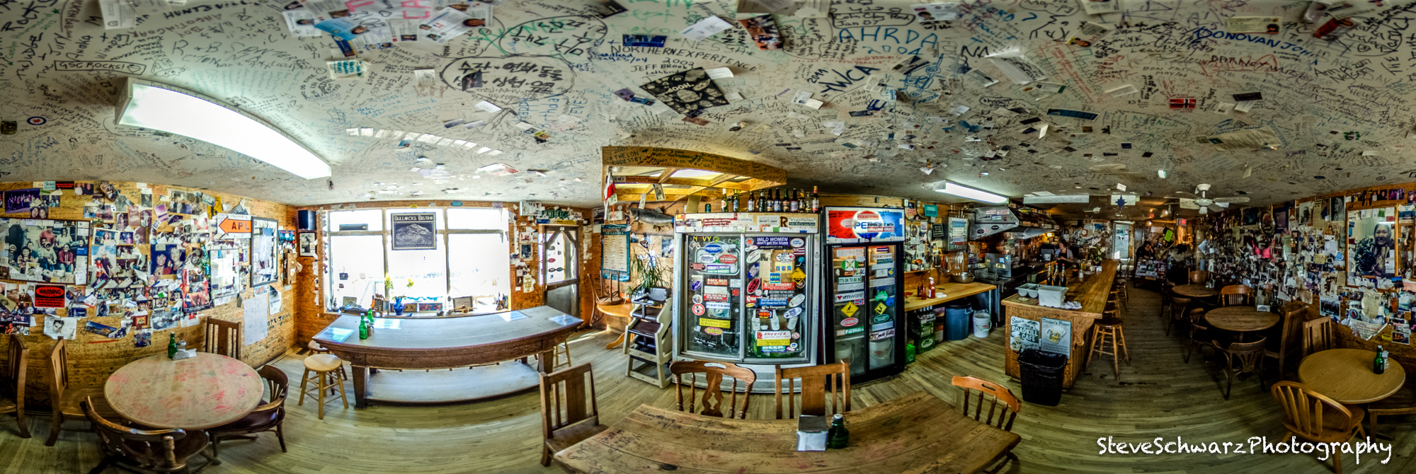 Click on the image to see it bigger.
To view a 360 degree animation of this scene, Click Here. This requires the QuickTime Player. Click the icon on the upper right corner of the animation to get a full view. Depending on network speed, the image may take a moment to load.
Camera gear: Nikon D700 and a Peleng 8mm lens on a custom monopole. Four pictures were combined to create the panorama images on this page.

To celebrate May Day (May 1st) and the coming of spring, I headed up MacEvoy Rock in Yellowknife’s Old Town. Of the two hills in Old Town, Pilot’s Monument is higher and far more popular that MacEvoy Rock. For creating panoramas and a quite place to hang out, MacEvoy Rock suits me perfectly.
In this image, downtown Yellowknife is directly under the sun on the right side of the image. Pilot’s Monument is in the middle of the photo, and Back Bay is on the far left.
Click on the image for a larger view.

Click ‘back’ on your browser to return to this page.
To view the 360 degree animation. Click Here This requires the QuickTime Player. Click the icon on the upper right corner of the animation to get a full view.
Compare to Panorama from July 12, 2011.
Camera gear: Nikon D700 and Nikon 20mm/2.8 lens on a monopole. 12 pictures were combined to create the panorama images.

It is a tradition that a large number of Yellowknife women organize and participate in their own triathlon. It is not a typical triathlon with race officials, spectators, time clocks and fast transitions. The triathlon includes a 20km bike, canoeing and running events. Among other things, what makes this triathlon different is the lunch break – champagne, caviar, fine cheese, and of course the skinny dip in a secret location !. This photo shown some of this years participants at the start of the event. It is not my best panorama, the ladies were anxious to get going and back-light sun in one of the images washed out one of the photos.
Click on the image for a larger view.
A circle of friends – ready to go biking…

Click ‘back’ on your browser to return to this page.
Camera gear: Nikon D700 and Samyang/Bower 8mm on a 7 foot pole. Four pictures were combined to create the panorama images.

During a lunch break during a beautiful sunny day, I grabbed my camera and panorama pole and ran up MacEvoy Rock in Yellowknife’s Old Town. The view from the top of the hill includes downtown Yellowknife, and great views of both Yellowknife Bay (center part of panorama), and Back Bay.

Click ‘back’ on your browser to return to this page.
To view the 360 degree animation. Click Here This requires the QuickTime Player. Click the icon on the upper right corner of the animation to get a full view.
Camera gear: Nikon D700 and Samyang/Bower 8mm on a 7 foot pole. Four pictures were combined to create the panorama images.
Early morning downtown Yellowknife on June 22, 2011. I am standing in the middle of Franklin Avenue. I would not recommend doing this during normal hours. At 5:00 am in the morning there were fortunately not too many cars.

The orange building is YK Centre, blue building is Northern Images (art gallery), and the white office tower is the Laing building.
Click ‘back’ on your browser to return to this page.
To view the 360 degree animation. This requires the Quicktime Player. Click the icon on the upper right corner of the animation to get a full view. Camera gear: Nikon D200 and Nikon 14mm/2.8, Nodal Ninja 5 panoramic head and Manfrotto tripod.
This panorama shows part of the Old Town of Yellowknife. I am standing in the middle of the channel, on approximately four feet of ice. On the left side of the photo below the large red and white houseboat is tied up to the Government dock. Pilots Monument is at the top of the hill behind the red building on the Government dock.
At the center of the photo, the Fishplant is a long white barge, and is anchored to Jolliffe Island. Several other barges and houseboats are anchored near Jolliffe island.
The office towers of downtown Yellowknife can be seen at the right side of the photo.
Click on the image for a larger view, and click on the image to zoom-in.

Click ‘back’ on your browser to return to this page.
To view the 360 degree animation. This requires the Quicktime Player
Use the left – right arrows on your keypad to rotate the field of view.
This is a 360 degree view of Old Town Yellowknife from Niven Hill. Click on the image for a larger view, and ‘back’ on your browser to return to this page. Select the link below to see a animated 360 degree view.

To view the 360 degree animation. Click Here. Use the mouse to control speed and look direction. Black spots in the sky are not UFO’s, but dust on the camera sensor… ;<
